Drone Sensing
- Advanced HD Camera Capturing Technology;
- Digital Image Processing Technology; and
- Advanced GPS navigation system.
This system can also be attached to an UAV (Unmanned Aerial Vehicle)
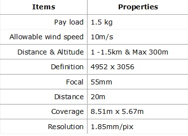
The specification of UAV is summarized in Table 1.
The waypoints were set with GPS_based to make the UAV fly automatically through the desired points. Combining with reference RTK_GPS, the UAV can be directed to return to the original location with an accuracy of several millimeters. Integrating with advanced HD Camera Capturing Technology and 3D Orthogonal Digitalized Image Processing, crack width can be captured with an accuracy of 0.1mm or better. Furthermore, by utilizing Augmented Reality technique, captured images can be presented in a live, direct, view of physical perspective, and real-world environment.The described integrated system can perform infrastructure inspection at both micro and macro scales. The applicability of this system was confirmed through its deployment in numerous types of bridges. The monitoring results on Tower Top, Bridge Deck and the images recorded along the tower of the Oshiba bridge at Hiroshima, Japan are shown on this page.The asset management scheme is introduced by capturing structural parameter changes, e.g., crack distribution. The crack distribution database contributes to estimate structural deterioration symptoms. This measurable information can eventually guide capital investment and investment prioritization within a limited-budget asset management plan.
Please double click on the Video to enlarge its view
[Courtesy of Keisoku Research Consultant]
Please double click on the video to enlarge its view
[Courtesy of Keisoku Research Consultant]


